Value pick
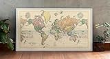
Stanford's World Map 1900 - Historical Map Print - 36in x 19in
Historic Pictoric option positioned in the budget range for a cleaner shortlist.
$39.99
Budget range
Shopper rating coming soon
Why shoppers consider it
- Full-color world map from 1900 by Edward Stanford, a renowned London cartographer, showing political boundaries and geography of the Gilded Age.
- Dissected into 40 sections and mounted on linen, originally folded into a cloth case—now available as a high-quality historical map reproduction.
- Perfect for history enthusiasts, educators, and collectors interested in turn-of-the-century cartography and global exploration.
- FINE ART PRINT QUALITY: Printed on heavyweight 230gsm matte paper with archival giclée inks for crisp detail, rich tonal depth, and long-lasting display quality suitable for home, office, or gallery-style framing.
Questions worth asking
- Does this home & kitchen fit the way you actually plan to use it?
- Does the current price still feel worth it against the other options you like?
- Do shopper reviews make this feel like a confident buy?